PODCASTS > Arcat Detailed Podcast Episode
130: Multi-block Design | Chicago Riverwalk and DuSable Park
47m 48s |
In this episode, Cherise is joined by Carol Ross Barney, FAIA, Founder and Design Principal at Ross Barney Architects – a Chicago-based architecture, urban design, and landscape architecture studio. They discuss the Chicago Riverwalk and DuSable Park, both in Chicago, IL.
For over 15 years, Ross Barney Architects has helped guide the transformation of the Chicago Riverwalk—a journey that turned a neglected industrial edge into one of the city’s most beloved public spaces. Once a forgotten stretch of dock and concrete, the Riverwalk now invites people to stroll, gather, and experience the city from a new perspective. By implementing a multi-block design, what once was a string of isolated spaces became a continuous path—a civic corridor full of life.
For over 15 years, Ross Barney Architects has helped guide the transformation of the Chicago Riverwalk—a journey that turned a neglected industrial edge into one of the city’s most beloved public spaces. Once a forgotten stretch of dock and concrete, the Riverwalk now invites people to stroll, gather, and experience the city from a new perspective. By implementing a multi-block design, what once was a string of isolated spaces became a continuous path—a civic corridor full of life.
Click here for the extended length interview on YouTube


Carol Ross Barney, FAIA, HASLA, the 2023 American Institute of Architects Gold Medal recipient, is an architect, urbanist, mentor, and educator, and has relentlessly advocated that excellent design is a right, not a privilege.
Dedicated to design of public buildings and spaces, her exploration into the power of how the built environment can improve our daily lives has produced distinctive structures and places that have become cultural icons.
H3- Project Name and Location: Chicago Riverwalk and DuSable Park, Chicago.
The Chicago Riverwalk and the new DuSable Park are both icons for the City of Chicago.
For the last 15+ years Ross Barney Architects has been the steward for the communal vision and design excellence of the Chicago Riverwalk; the transformation of a neglected and underutilized remnant of the industrial era dock and promenade along the Chicago River. This is the story of a changing City.
The Chicago Riverwalk is a work in progress. The river itself has changed significantly since the arrival of Americans in the early nineteenth century. Straightened, edges hardened, and famously redirected, the Chicago River has figuratively and literally been bent to serve us. That service included, and continues to include, commercial transportation and wastewater management. At least as early as Burnham and Bennett’s 1909 ”Plan of Chicago”, the Main Branch of the river was also envisioned as a place for strolling, along the lines of a Parisian boulevard.
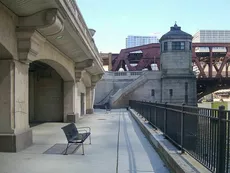
The construction of Wacker Drive in the 1920s began the realization of Burnham and Bennett’s vision with the introduction of a neo-Classical language along the south bank of the Main Branch. An unfortunate consequence of the Plan’s proposal to separate commercial traffic through the building of a network of two-level streets, was that the new drive was more than 20 feet above the river. Although accessible by stair, each block of the river would remain isolated from its neighbor for almost a century.
Between 1909 and 2009, the vision for the Chicago River, as well as its condition, changed. What is considered possible and desirable to do in and next to an urban river has changed. Starting in 2002 and continuing through 2016, the eight blocks of the river between Michigan Avenue and Lake Street have been significantly redesigned and rebuilt.
The transformation began with a series of small improvements undertaken by the City through the Chicago Department of Transportation. The historic DuSable (Michigan Avenue) Bridge railings were restored. A new memorial honoring the Vietnam War dead from Illinois was constructed at river level at Wabash Avenue. Initial funding for the planning and funding of these small projects came from a basket of grants controlled by CDOT as well as downtown tax increment financing monies. While most people do not think of greenspace and parks as the purview of transportation departments, CDOT proved to be uniquely suited to plan and manage the Riverwalk construction. The Chicago River like most urban rivers is controlled as a Federal waterway, CDOT was required to coordinate approvals from the Army Corps of Engineers, the Coast Guard and ultimately the United States Congress since legislation was required to reconfigure the river channel.
The Riverwalk is inherently sustainable, beginning with the very small percentage of space that is conditioned. In the River Theater, rainwater is harvested for use in irrigating plants at that location. More importantly, the Riverwalk contributes to the City’s resilience by holding stormwater during major rain events. As a transportation modal shift from the motor vehicle to the pedestrian and otherwise human-powered, the Riverwalk improves the environment along the Chicago River and provides a low-stress and more sociable alternative to travelling along the busy Wacker Drive. In addition to environmental sustainability, the Riverwalk contributes to physical activity, human interaction, and an overall improvement in public health.
Three physical changes were made for the Riverwalk to become a civic place that successfully harnesses improved water quality and our more informal society. The most important of these is that each block is connected to the next without having to cross the intervening street. This is done with “underbridges”. A second improvement is visible and Americans with Disabilities Act-compliant connections between the Riverwalk and the streets, above. Third, for six of the eight blocks, the City received permission through the US Congress to extend the Riverwalk 25 feet into the river.
Part of the success of the Riverwalk is that there is programming of the space, including commercial outlets to eat, drink, or to rent a kayak. When integrating commerce into a public space, question to be asked include: will this activity improve the experience for the general public? Will it be more interesting? Safe? Will non-patrons feel welcome in the space?
Commerce and public space are intertwined in Chicago and this is a good thing. We must ask the right questions of our public spaces. Apart from, and in addition to, improving the quality of life for our residents, public spaces work best as “loss leaders”. We cannot ask them to be financially self-sufficient. The economic benefit of public spaces is the value that they create in adjacent private properties. The argument is that these properties will generate income, employment, and taxes that more than offset the investment in public infrastructure.
A portion of the Chicago Riverwalk was paid for with federal funding and a portion with federal loans. We are now asking that the concessions on the Riverwalk cover the debt service and management of the space. In contrast, Millennium Park was almost half paid for with private donations and an endowment was created for its maintenance.
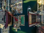
The latest Riverwalk section, from State Street to LaSalle Street opened during the summer of 2016, was eagerly anticipated in both traditional and social media. This section is more elaborate in programming and materials than earlier sections and includes retail food and beverage operations.
The popularity of the Chicago Riverwalk, while not unexpected, has been amazing, ratifying the idea that it is this type of public space: found in and created from the neglected pieces of our cities, is essential to the quality of urban life. It is an important direction in our future.
DuSable Park is a 3.5 acre space where the Chicago River and Lake Michigan meet. Named in honor of Jean Baptiste Pointe DuSable, the first non-native settler and “Founder of Chicago”, DuSable Park will become an overdue acknowledgement of the city’s history and an iconic public space.
The new DuSable Park design includes an ongoing engagement process with the community and stakeholders. The process began with in person, online and on-site engagements on a City-wide basis. The quality and depth of these listening sessions with thousands of committed and engaged residents and interest groups helped inform the design.
Sited on an area of lake fill, the park was home to various industrial uses beginning in the late 1800’s. The Chicago Dock and Canal Trust Planned Development established the site as a park, and in 1987 Mayor Harold Washington dedicated the site.
DuSable Park will be connected to the Flyover path for pedestrian and bicycle access.
An inscribed pavilion marks the spiritual center of the park, activated year-round with gatherings and celebrations. The size of the pavilion recalls the primary residence within DuSable’s estate, a frame house measuring 40’ x 22’.
Connections to the river esplanade beneath DuSable Lake Shore Drive and the Lakefront Path provide access to the park, linking this oasis with the city that surrounds it.
DuSable park is positioned as both a critical piece of Chicago’s public Lakefront and a cap to Chicago’s Riverwalk.


Carol Ross Barney, FAIA, Founder and Design Principal at Ross Barney Architects
Carol Ross Barney, FAIA, HASLA, the 2023 American Institute of Architects Gold Medal recipient, is an architect, urbanist, mentor, and educator, and has relentlessly advocated that excellent design is a right, not a privilege.
Dedicated to design of public buildings and spaces, her exploration into the power of how the built environment can improve our daily lives has produced distinctive structures and places that have become cultural icons.
H3- Project Name and Location: Chicago Riverwalk and DuSable Park, Chicago.
The Chicago Riverwalk and the new DuSable Park are both icons for the City of Chicago.
Chicago Riverwalk:
For the last 15+ years Ross Barney Architects has been the steward for the communal vision and design excellence of the Chicago Riverwalk; the transformation of a neglected and underutilized remnant of the industrial era dock and promenade along the Chicago River. This is the story of a changing City.
The Chicago Riverwalk is a work in progress. The river itself has changed significantly since the arrival of Americans in the early nineteenth century. Straightened, edges hardened, and famously redirected, the Chicago River has figuratively and literally been bent to serve us. That service included, and continues to include, commercial transportation and wastewater management. At least as early as Burnham and Bennett’s 1909 ”Plan of Chicago”, the Main Branch of the river was also envisioned as a place for strolling, along the lines of a Parisian boulevard.
The construction of Wacker Drive in the 1920s began the realization of Burnham and Bennett’s vision with the introduction of a neo-Classical language along the south bank of the Main Branch. An unfortunate consequence of the Plan’s proposal to separate commercial traffic through the building of a network of two-level streets, was that the new drive was more than 20 feet above the river. Although accessible by stair, each block of the river would remain isolated from its neighbor for almost a century.
Between 1909 and 2009, the vision for the Chicago River, as well as its condition, changed. What is considered possible and desirable to do in and next to an urban river has changed. Starting in 2002 and continuing through 2016, the eight blocks of the river between Michigan Avenue and Lake Street have been significantly redesigned and rebuilt.
The transformation began with a series of small improvements undertaken by the City through the Chicago Department of Transportation. The historic DuSable (Michigan Avenue) Bridge railings were restored. A new memorial honoring the Vietnam War dead from Illinois was constructed at river level at Wabash Avenue. Initial funding for the planning and funding of these small projects came from a basket of grants controlled by CDOT as well as downtown tax increment financing monies. While most people do not think of greenspace and parks as the purview of transportation departments, CDOT proved to be uniquely suited to plan and manage the Riverwalk construction. The Chicago River like most urban rivers is controlled as a Federal waterway, CDOT was required to coordinate approvals from the Army Corps of Engineers, the Coast Guard and ultimately the United States Congress since legislation was required to reconfigure the river channel.
The Riverwalk is inherently sustainable, beginning with the very small percentage of space that is conditioned. In the River Theater, rainwater is harvested for use in irrigating plants at that location. More importantly, the Riverwalk contributes to the City’s resilience by holding stormwater during major rain events. As a transportation modal shift from the motor vehicle to the pedestrian and otherwise human-powered, the Riverwalk improves the environment along the Chicago River and provides a low-stress and more sociable alternative to travelling along the busy Wacker Drive. In addition to environmental sustainability, the Riverwalk contributes to physical activity, human interaction, and an overall improvement in public health.
Three physical changes were made for the Riverwalk to become a civic place that successfully harnesses improved water quality and our more informal society. The most important of these is that each block is connected to the next without having to cross the intervening street. This is done with “underbridges”. A second improvement is visible and Americans with Disabilities Act-compliant connections between the Riverwalk and the streets, above. Third, for six of the eight blocks, the City received permission through the US Congress to extend the Riverwalk 25 feet into the river.
Part of the success of the Riverwalk is that there is programming of the space, including commercial outlets to eat, drink, or to rent a kayak. When integrating commerce into a public space, question to be asked include: will this activity improve the experience for the general public? Will it be more interesting? Safe? Will non-patrons feel welcome in the space?
Commerce and public space are intertwined in Chicago and this is a good thing. We must ask the right questions of our public spaces. Apart from, and in addition to, improving the quality of life for our residents, public spaces work best as “loss leaders”. We cannot ask them to be financially self-sufficient. The economic benefit of public spaces is the value that they create in adjacent private properties. The argument is that these properties will generate income, employment, and taxes that more than offset the investment in public infrastructure.
A portion of the Chicago Riverwalk was paid for with federal funding and a portion with federal loans. We are now asking that the concessions on the Riverwalk cover the debt service and management of the space. In contrast, Millennium Park was almost half paid for with private donations and an endowment was created for its maintenance.
The latest Riverwalk section, from State Street to LaSalle Street opened during the summer of 2016, was eagerly anticipated in both traditional and social media. This section is more elaborate in programming and materials than earlier sections and includes retail food and beverage operations.
The popularity of the Chicago Riverwalk, while not unexpected, has been amazing, ratifying the idea that it is this type of public space: found in and created from the neglected pieces of our cities, is essential to the quality of urban life. It is an important direction in our future.
DuSable Park, Chicago, Illinois
DuSable Park is a 3.5 acre space where the Chicago River and Lake Michigan meet. Named in honor of Jean Baptiste Pointe DuSable, the first non-native settler and “Founder of Chicago”, DuSable Park will become an overdue acknowledgement of the city’s history and an iconic public space.
The new DuSable Park design includes an ongoing engagement process with the community and stakeholders. The process began with in person, online and on-site engagements on a City-wide basis. The quality and depth of these listening sessions with thousands of committed and engaged residents and interest groups helped inform the design.
Sited on an area of lake fill, the park was home to various industrial uses beginning in the late 1800’s. The Chicago Dock and Canal Trust Planned Development established the site as a park, and in 1987 Mayor Harold Washington dedicated the site.
DuSable Park will be connected to the Flyover path for pedestrian and bicycle access.
An inscribed pavilion marks the spiritual center of the park, activated year-round with gatherings and celebrations. The size of the pavilion recalls the primary residence within DuSable’s estate, a frame house measuring 40’ x 22’.
Connections to the river esplanade beneath DuSable Lake Shore Drive and the Lakefront Path provide access to the park, linking this oasis with the city that surrounds it.
DuSable park is positioned as both a critical piece of Chicago’s public Lakefront and a cap to Chicago’s Riverwalk.
Project Team List:
DuSable Park Design Alliance:
- Ross Barney Architects
- Brook Architecture
- Sylvain Studios (Art Curator)
- Dr. Christopher Reed (Historian and DuSable Scholar)
- MBDB (Community Engagement)
- sColeman Design (Graphics and Wayfinding)
- Dynasty Group (Surveying)
- David Mason (Civil and Structural Engineering)
- Wang Engineering (Engineering)
- Alfred Benesch (Marine Engineering)
- Delta Engineering (Electrical Engineering)
- Hugh Associates (Lighting Design)
- Concord Group (Cost Estimation)
Chicago Riverwalk
- Owner: City of Chicago, Department of Transportation
Phase I
- Ross Barney Architects (Architecture)
- Jacobs / Ryan Associates (Landscape Architect)
- Collins Engineers (Prime Consultant, Structural and Civil Engineering)
Phase II
- Ross Barney Architects (Architecture)
- Sasaki (Prime Consultant, Landscape Architecture, Civil Engineering)
- Benesch (Construction Management, Marine and Structural Engineering)
- Jacobs / Ryan Associates (Associate Landscape Architect)
- Conservation Design Forum (River Ecology)
- David Solzman (Historian)
- Delta Engineering Group (Mechanical, Electrical, Plumbing)
- Dynasty Group (Surveyor)
- GeoServices (Geotechnical)
- Infrastructure Engineering (Civil Engineering)
- Moffat + Nichol (Boating / Waterway)
- Rubinos & Mesia Engineers (Structural Engineering)
- Schuler Shook (Lighting)
Phase III
- Ross Barney Architects (Architecture)
- Sasaki (Prime Consultant, Landscape Architecture, Civil Engineering)
- Benesch (Construction Management, Marine and Structural Engineering)
- Jacobs / Ryan Associates (Associate Landscape Architect)
- Delta Engineering Group (Mechanical, Electrical, Plumbing
- Fluidity (Water Feature Design)
- Infrastructure Engineering (Civil Engineering)
- Rubinos & Mesia Engineers (Structural Engineering)
- Schuler Shook (Lighting
DuSable Park:
- Owner: Chicago Park District
